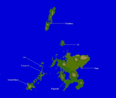
North Kyusu[]

Labelled map of North Kyusu. Int'l airports in bold. small airports in smaller font.
North Kyusu is the third-largest default map in YSFlight, and has no shortage of destinations. It is unique for having several airports higher then sea level. Civilian pilots will have the opportunity to fly to large, medium and small airports, and during night or low visibility, pilots will need to remember the elevation of airports as an added challenge.
Nagasaki:
- Rwy 14/32, ILS rwy 32 only
- Apron max capacity 4 large airliners
- Fuel available
Nagasaki 2:
- Rwy 18/36
- Fuel available
Saga:
- Rwy 11/29: ILS both ends, PAPI visual approach path indicator both ends.
- Fuel available
- Two aprons midfield, one medium-sized and one small
- Main apron max capacity 3 large airliners
- Secondary apron has a narrow taxiway, best use is for small aircraft or military use.
- Taxiways only go from aprons to centre of runway; aircraft must taxi on runway for full length takeoffs. There is a turnaround bay at each end of the runway.
- Fuel available both aprons
Iki:
- Medium Airport
- Rwy 2/20
- Runway is short for medium airliners (B737 on landing) (stock A320 - with only 20% fuel - on landing)
- Apron max capacity 1 medium airliner.
Gotoh Fukue:
- Feild elevation: 270ft
- Terrain just west of airport
- Rwy 03/21: ILS rwy 3 only
- Apron midfield, max capacity 2 medium airliners
- No taxiway along runway, backtracking necessary, no lighting on taxiway or apron
- Fuel available
Kamigotoh:
- Medium Airport
- Field elevation 290ft
- Rwy 35/17 no ILS
- Runway too small for medium airliners (B737 on takeoff) regional aircraft only
- Apron at 35 end of rwy
- Fuel available
- Kamigotchi has no VOR but does have an NDB.
- From Goto Fukue, fly or follow VOR 040 for 27 miles
- From all other airports, fly toward Fukue VOR and listen for Kamigotoh NDB, once the signal is picked up, turn to home in on Kamigotoh.
Ojika:
- Small Airstrip
- Rwy 21/03
- Runway too short for any jet, suitable for small aircraft or regional props only
- Apron midfield, max capacity 2 small aircraft
- Fuel available
- From Kamigotoh, head 340 (almost straight out from Kamigotoh rwy 35)
- From Gotoh Fukue fly or follow VOR 025 for 30 miles
- From Nagasaki, fly or follow VOR 295 for 45 miles
Tsushima:
- Field elevation: 200ft.
- Rwy 14/32, ILS 32 only, PAPI visual approach path indicator both sides
- Terrain on right downwind for rwy 32
- Apron at 14 end of rwy.
- Fuel available
- From Nagasaki, fly or follow VOR 340, 87 miles